Saturday, April 4, 2015
Vacation or bootcamp? Up in the wee hours, throwing layers of clothes on in the dark, grabbing gear-laden backpacks and tripods, meeting as early as 4:20 am to caravan to vistas 15 minutes to an hour away, arriving in time to setup tripods and cameras while the night receded. We hoped to be rewarded with rich sunrise color and clouds to enliven the sky, to complement glowing hues of the signature red rock formations of the Southwest.
This was our routine for four mornings in a row during our April “Southwest and Navajo Country” photography workshop with Jack Graham, a professional landscape photographer based in Oregon.
The evenings were intensive as well, departing for sunset shoots in the late afternoon, returning in time for late dinners after dark, tumbling into bed exhausted, to rise 5-6 hours later. In between were image review sessions, cleaning gear of fine sand, downloading images, editing, rushed meals, leaving little time to shower and organize.
The major draw was to be in long-imagined signature sights of the Southwest at the optimal time for photography, in the company of guides as resources for both the particularities of the sites and photography in general.
Curious rock formations abound in the Four Corners area; tiny people in the distance give an idea of the scale of these natural obelisks
Our friend Greg joined us from Chicago for this adventure. I had been drawn to this particular workshop as a chance to finally see and shoot Antelope Canyon. My friend Susan was enthusiastic about a workshop to the Oregon Coast she had done the prior year with Jack. We had been to Monument Valley before, but the other destinations were all new to us. This was Greg’s first trip to northern Arizona.
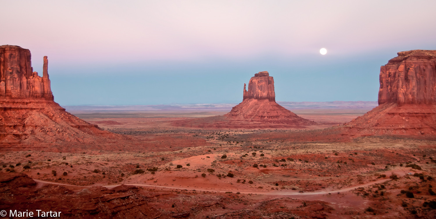
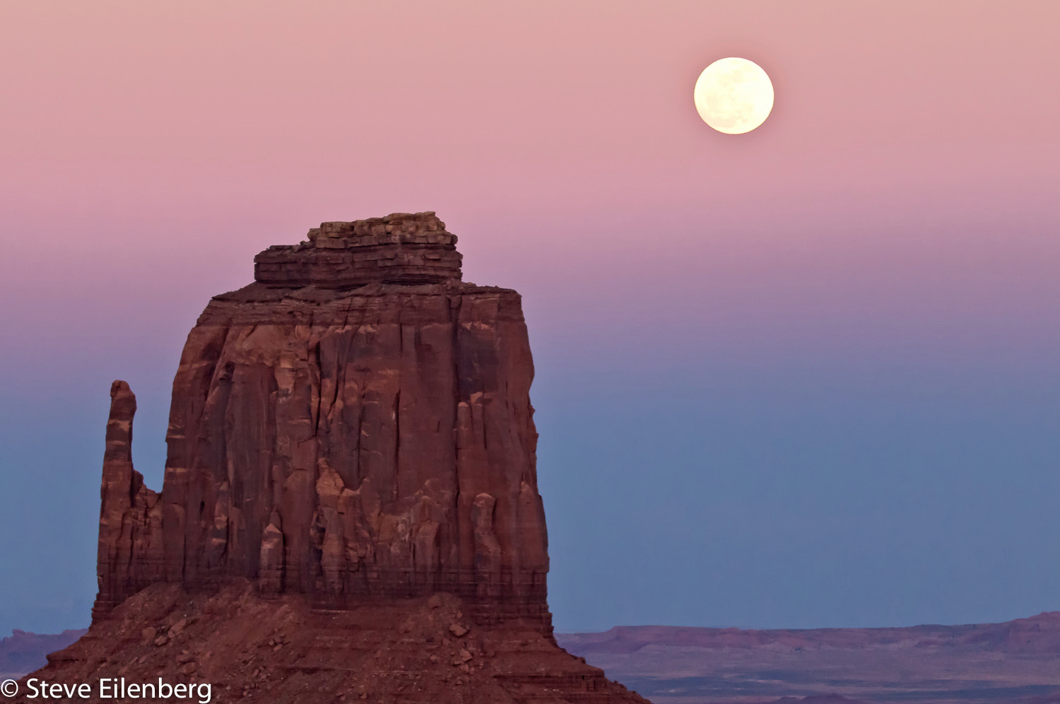
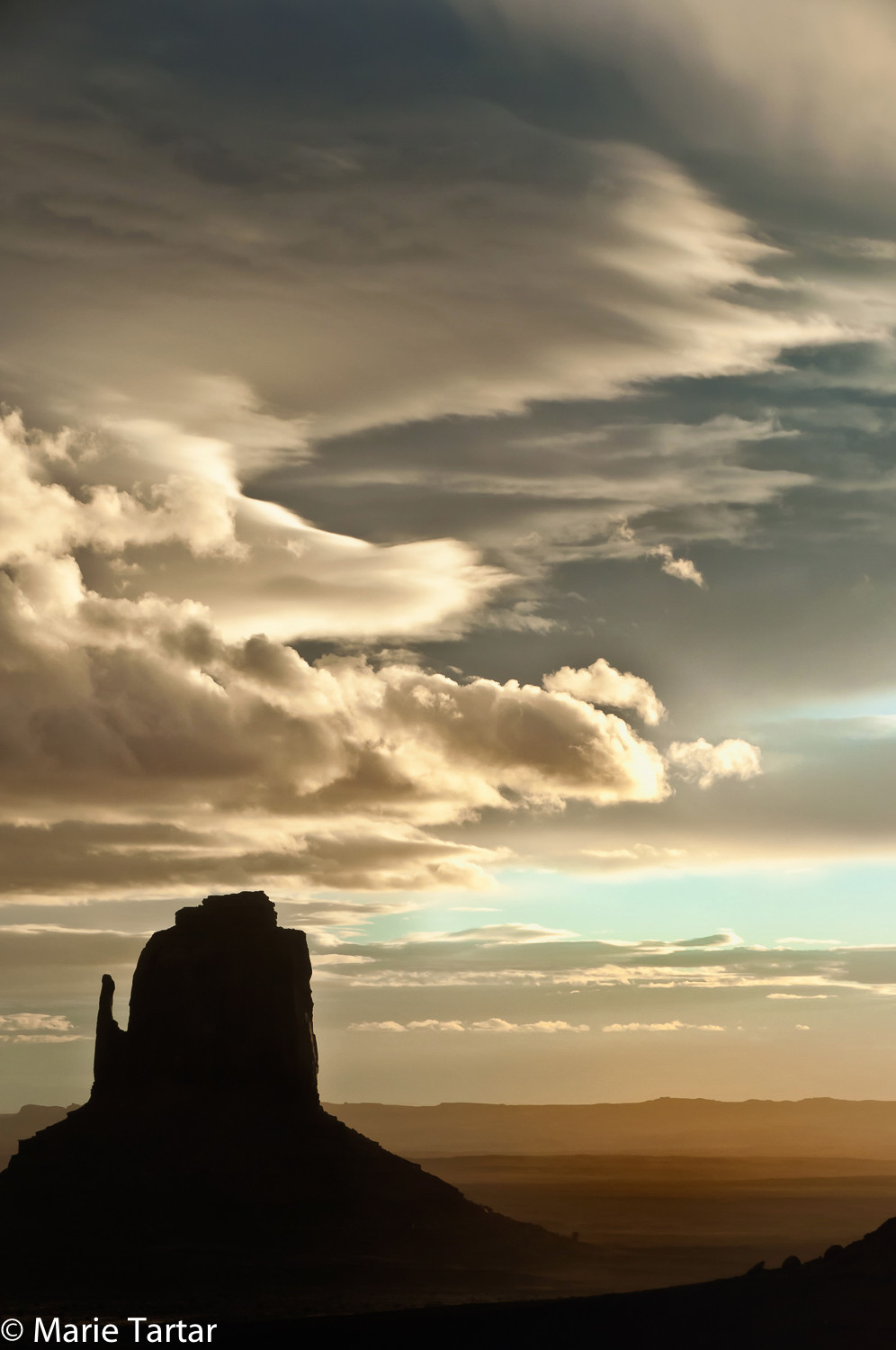
From our 2011 trip to Monument Valley, with a full moon
We arranged to rendezvous on Saturday before the Wednesday night start of the workshop. Steve and I would drive to Phoenix from San Diego, pick up Greg there and we would spend a few days showing Greg Sedona and the Grand Canyon before heading to Page.
Our Saturday start was not smooth.
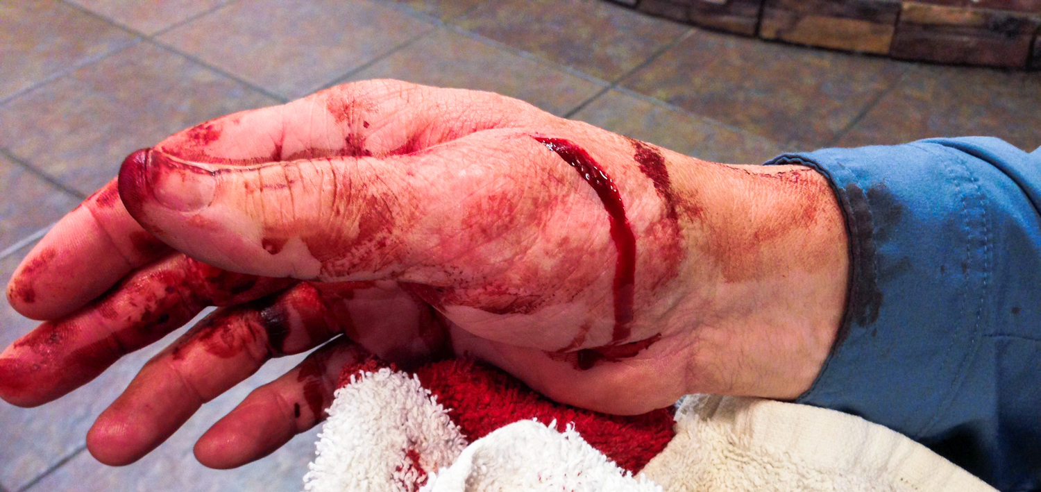
Steve wanted to have our own car for our workshop and so we drove, despite the fact that we had to replace our sandstorm-blasted windshield after our prior trip to Monument Valley. En route to Arizona, the car’s warning alarm indicated low tire pressure. We were near Yuma and pulled off. Instead of heading to the gas station as I expected, Steve steered into the Home Depot he had sighted from the freeway and I headed into the restroom. Returning 5 minutes later, Steve was at the rear of the car with a weird expression and clutching one hand. He muttered something about needing stitches. I didn’t think I heard him right, but then I noticed his hand was covered with blood, with a puddle on the asphalt and on the rear bumper.
“What did you DO!?”
“I cut myself.”
“Did you hit an artery?”
“Don’t think so.”
He had bought a tire pump with numerous tightly bound zipties needing to be released. Employing a multi-tool key chain knife, the result was not good. Commandeering the now bloody keys from him, I opened the car and found a washcloth in a door pocket, with which he wrapped his hand. A concerned and slightly nauseous looking couple who parked adjacent approached and told us where the hospital was, 5 minutes away.
I drove us to the hospital, dropped Steve off at Emergency and parked the car. After looking around, we decided maybe an Urgent Care would be better, and with Siri’s aid, got directions to nearby Northside Medical Clinic .
The empty lobby should have been a clue that maybe this wasn’t the best choice. The pleasant young practitioner introduced herself by first name, and wasn’t wearing a name badge. We guessed that she was a “health care provider”. While they were chasing down a suture kit, Steve washed blood clots off his hand. The wound irrigation was lackluster. After numbing Steve up, the practitioner was unable to suture his wound. She couldn’t pierce his skin with the suture to even start closing the wound. Her hand was shaking. One of the problems was that she was trying to use a hemostat instead of a needle holder. The needle repeatedly flew out of the hemostat with the proline suture material languishing on whatever unsterile object it encountered. After multiple attempts and several comments about Steve’s “tough skin”, she suggested we head back to the Yuma hospital. Disinclined to spend one more minute in Yuma, we continued our journey to Phoenix.
Greg was staying at the Valley Ho in Scottsdale, having arrived the night before, and from their front desk, we obtained a list of nearby medical facilities. By this time, it was 4-ish and most of the Urgent Cares were closed. A suggested hospital ER was only a mile away. The lobby appeared empty, but this turned out to be misleading, as the concealed-behind-doors emergency department turned out to be enormous and quite active.
While Steve was being treated, Greg and I decided to go have an early dinner at The Mission, the restaurant where we had planned to have lunch. It turned out to be practically next door to the hospital. It was pleasant on the patio and a nice place to recover from the trauma of the drive, the unexpected injury and tour of Arizona’s medical facilities.
The rest of the week’s activities went more as planned. For 2 days, we gave Greg an introduction to Sedona, with a mix of hiking, architectural high and low lights (Chapel of the Holy Cross and its over-the-top neighbor), favorite meals (lunch of reubens and the chopped salad at Wildflower, asparagus leek soup, salad in lemon chive vinaigrette dressing, roasted chicken and dessert of gingered shortcake with berries at Garland’s, and Steve’s famous eggplant paninis at home) and even a late afternoon shoot at Red Rock Crossing, the signature view of Cathedral Rock.
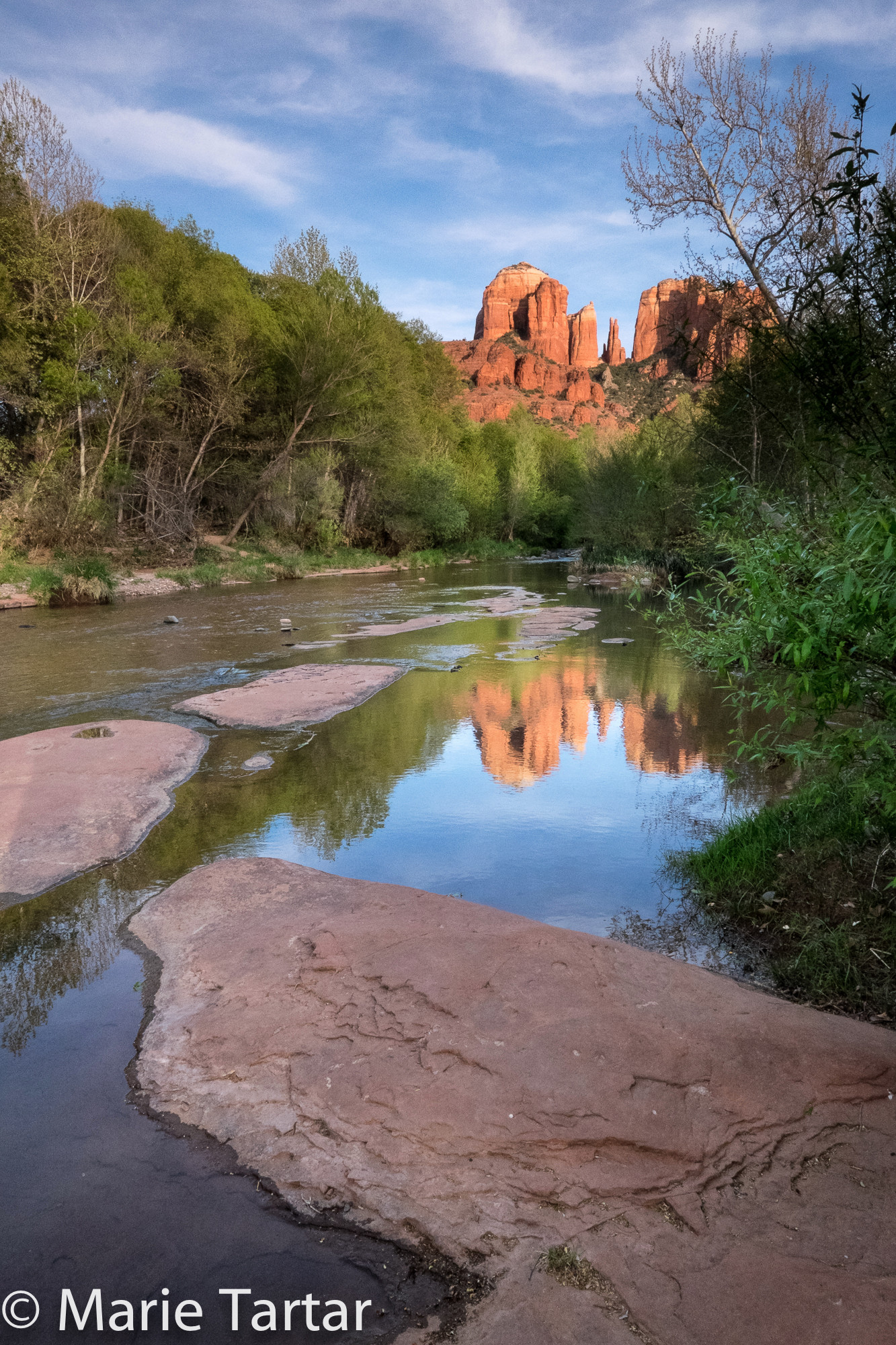
Cathedral Rock, the signature formation of Sedona, from Red Rock Creek Crossing
One morning, we hiked from the house, up to the Cibola Mitten thumb, and the next, we headed up canyon to a perennial favorite, West Fork of Oak Creek. Greg had brought Pisco Sour ingredients, and recreated the drink which began each dinner in Patagonia. He had to improvise, using maple syrup to formulate a version of a simple syrup. On discovering we didn’t have a cocktail shaker, he managed with a lime green Nalgene water bottle to agitate the Pisco, egg whites and limes into a delicious version of the signature drink of Chile and Peru (both countries claim it).
(Cooking in a second home, until it is fully furnished, is an ongoing process of discovery, of what tools you DON’T have. When our friends Cindy and Gerry were with us a few years ago, Steve, Cindy and I collaborated on a Moroccan meal for 8. Cindy and I discovered we didn’t have a pastry brush, AFTER thawing the filo sheets (which have to be mobile enough to open but not dried out so as to crack) for a chicken version of pastilla . Each sheet of filo has to be brushed with melted butter and we were committed. We salvaged the situation with strips of torn paper towels, dipping them into the melted butter, and although not efficient or elegant, the dish turned out great, a wonderful combination of the savory chicken mixture, offset by the crispy and buttery pastry and crunch of almonds, all topped with a dusting of cinnamon.)
Tuesday, April 7, 2015
After a morning meeting with interior designer Jennifer and contractor Chris regarding our evolving renovation of the Sedona guesthouse (our plans to change out the toilet to an up-to-date model like in the main house somehow culminating in demolishing the bathroom and ultimately, the kitchen as well), we were off to the Grand Canyon one day prior to the workshop’s Wednesday night start.
We loaded up the Audi with 3 camera bags, 2 suitcases, a white box filled with snacks, drinks, jackets, gloves and hats and headed north to the Grand Canyon. Of course, our passing through Flagstaff was timed to coincide with lunch at destination burger joint, Diablo Burger, which sources its meat from Diablo Ranch and serves up the medium rare burgers on DB branded English muffins. I opted for my usual, the health food loaded Vitamin B, with blue cheese, bacon and beets. This time, I remembered to ask for the double fried frites to be lightly salted.
We had timed our arrival at Grand Canyon to be there to walk along the rim and shoot the sunset, with dinner at El Tovar not scheduled until 8:45 pm., after dark. We hadn’t really banked on our hotel, the “Grand,” being outside the park, figuring this out after dropping Greg off to check in at El Tovar and circling looking for parking. We were surprised how the park wasn’t at all empty when we were there in the cold of January, but it was just after New Year’s and a fresh snow, but that was nothing compared to how completely booked up the park seemed to be in April, at least in terms of hotel choices.
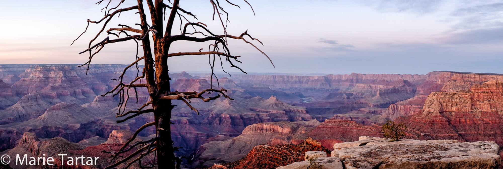
Only a panoramic view seems to capture the majesty of the Grand Canyon
I had to laugh (internally of course) at Greg’s initial timidity shooting on the rim of the canyon. He sounded more than a little wigged out as we crawled onto craggy formations free of the maddening crowd in search of the most interesting vantage points from which to depict the majestic canyon. I think I heard a couple of “Mama” exclamations from his general direction.
As usual, the El Tovar dinner sounded better on paper than it was executed, but given where we were headed, it was a kind of last supper.
Wednesday, April 8, 2015
Exercising our photographic muscles in anticipation of the coming workshop, we voluntarily set the alarm for dark o’clock to shoot the sunrise.
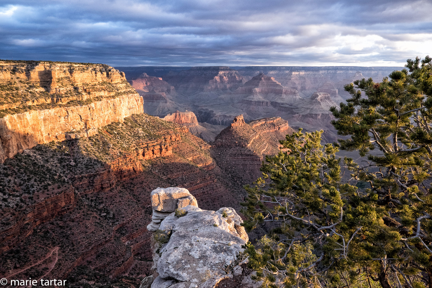
Grand Canyon, at sunrise
Steve and I caught a couple of hours of sleep afterwards, while Greg tuned in to a conference call.
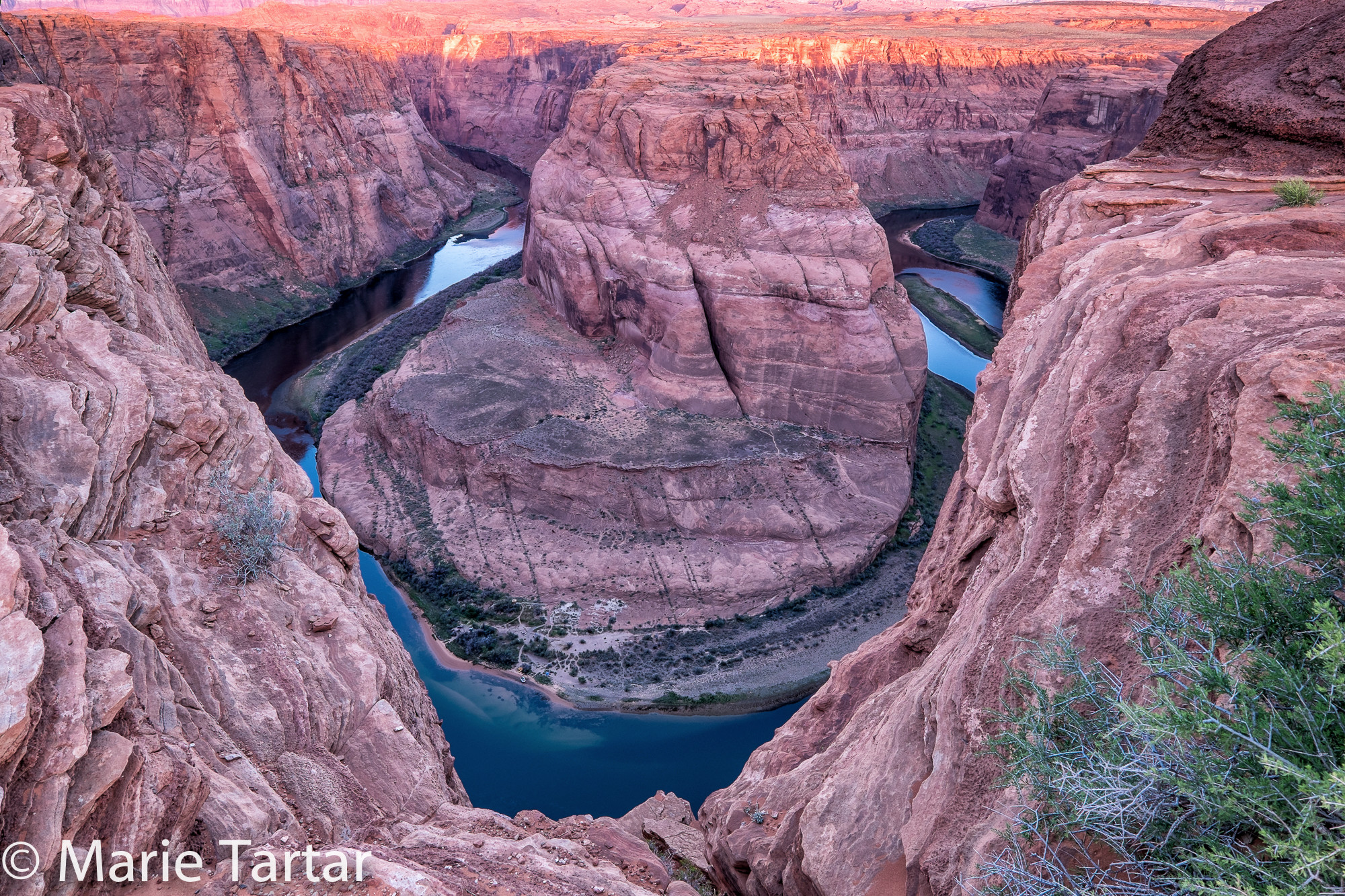
We approached Page in mid-afternoon, and stopped off to check out Horseshoe Bend on the way into town. This is a stratified red rock perch high above a signature horseshoe-shaped bend in the Colorado River. We knew we would be shooting there during the workshop, but wanted to see and scout it. As it happens, our workshop shoot was for sunrise, so it was a nice contrast to shoot it in the late afternoon, into the sun. Polarizing filters helped with the shine of the river’s surface far below, but completely taming the flare was difficult to achieve, if not impossible.
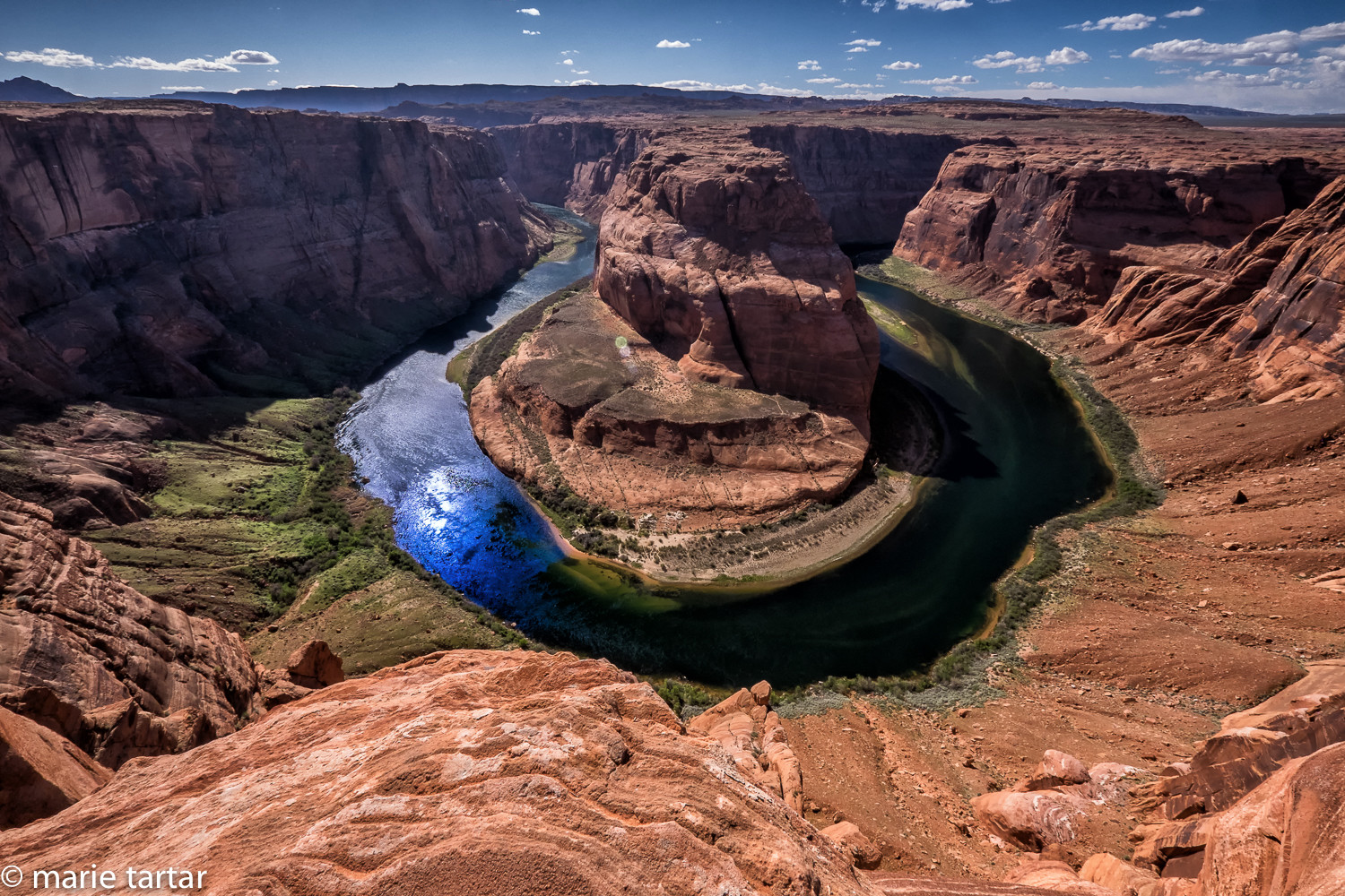
Horseshoe Bend, a jaw-dropping vista, in late afternoon
A distinctive feature of Page is what I called “miracle mile” and locals call “Holy Curve,” for the numerous churches which line this stretch, established for workers who came to build the nearby Glen Canyon dam. After locating our base for the workshop, a comfortable and reasonably attractive Marriot, situated around a courtyard that we never once had a chance to sit in, we caught an early quick bite at the hotel’s restaurant before the meet and greet at 7 pm. We didn’t make that mistake again, the food being uninspiring, but then again, this isn’t a culinary destination and many of the local options we tried were eminently forgettable. Let’s just say there was a stark contrast between the limpid, too cold guacamole we shared and the tableside version we had had a few days earlier in Scottsdale. There are good dining choices in Sedona and Flagstaff, even Winslow, but after that…well, northern Arizona and the Navajo Nation isn’t really known for its cuisine. The scenery, on the other hand, is truly unique and world-class in its variety and splendor. We heard a mix of accents during our stay, encountering many Chinese at Horseshoe Bend, and hearing Japanese, French, German and other languages in Antelope Canyon.
Our two leaders for the workshop were a seasoned veteran, Jack Graham, from Washington State, and a rising star local, Mylo Fowler. Jack has been a professional photographer leading tours for 20-something years after retiring from a first career in electronic sales. He is genial giant of a man, who brought lovable Shrek to my mind. Mylo is a remarkably accomplished 32 year old multiply-sponsored professional photographer, multi-lingual (including Navajo and French), and musical (didgeridoo and Navajo flute), in addition to being quite personable.
Despite a newly detached retina needing immediate surgical attention, Jack was very attentive to individual’s questions and quite encouraging, while diplomatically pointing out opportunities for improvement and alternate choices during image reviews.
The group consisted of us, a group of retired older, white or grey or sparsely haired men friends from a camera club in Cleveland, 2 Indian-American male doctor friends, 3 married women leaving spouses and children behind in the Midwest and several mature Canadian men, one of whom had done this workshop or a version of it 8 times! Among the participants, doctors were heavily represented. In addition to Steve and me and the Indian doctors were the former chairman of radiology at Case Western and a retired South African obstetrician-gynecologist. The hardware the group was shooting was impressive too: many high end Canons and Nikon D800s and 810s. I was the only one shooting a Fuji X-T1, the camera system Jack also favors.
The group was larger than I expected at 18, but we were divided into 2 groups when it mattered most, namely when we shot Upper and Lower Antelope Canyons on consecutive days. We also carpooled to many destinations, for which we were grateful, as a number of the roads were sandy, or rocky or otherwise squirrelly. The 3 of us were paired with Joe, a retired forensic accountant from Boulder, a 70-something fly-fishing enthusiast and self-declared “right-of-Attila-the-Hun conservative.” Joe was quite accomplished, not only as a photographer, but as a driver, not just long-distance (he drove from Colorado) and on dicey roads, but also is a veteran drone pilot!
Jack runs a tight workshop. If the schedule says 4:50 am departure, that meant, vehicles rolling out of the parking lot at 4:50, and indeed they did. We were expected to be assembled and loading gear 10 minutes before departure. This policy stood us in good stead in terms of arriving with enough time to set up and be ready as the sky lightened.
Thursday, April 9, 2015
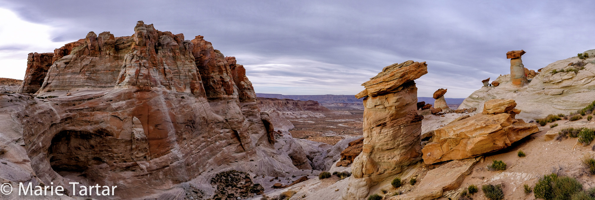
Our first morning’s shoot was on the southern approach into town, dubbed Dykinga’s Rocks, named for Jack Dykinga, a nature photographer well known to admirers of Arizona Highways magazine. The site features a series of curious conical rock formations. We had sweet pink light on them for just a few short minutes.
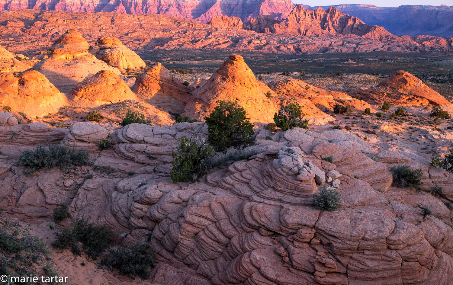
This formation, south of Page, Arizona, is dubbed “Dykinga’s Rocks” for famed Arizona Highway photographer, Jack Dykinga
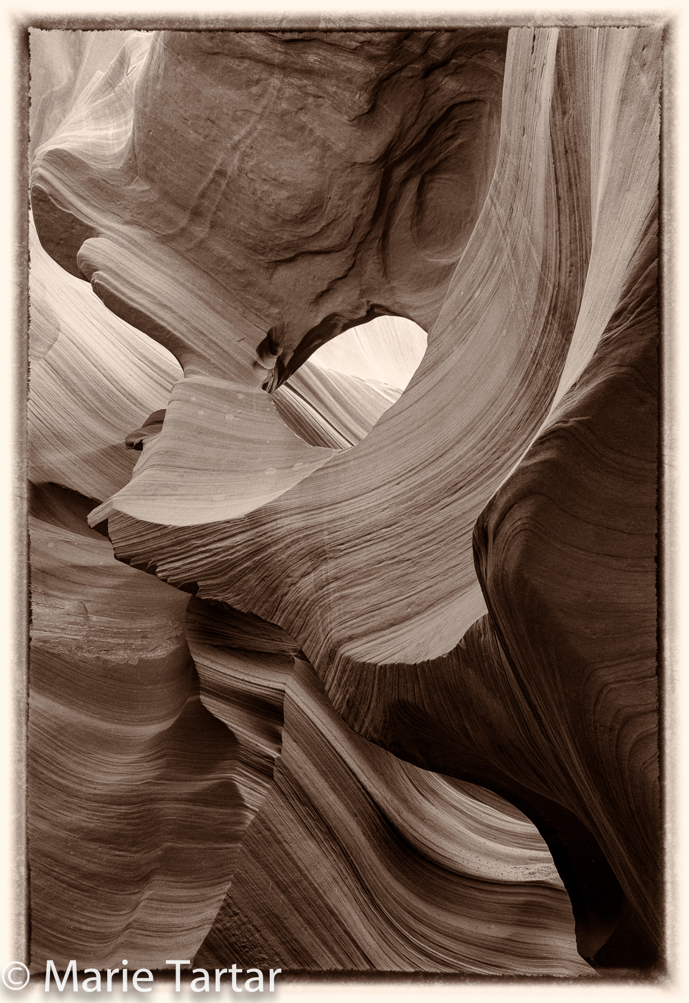
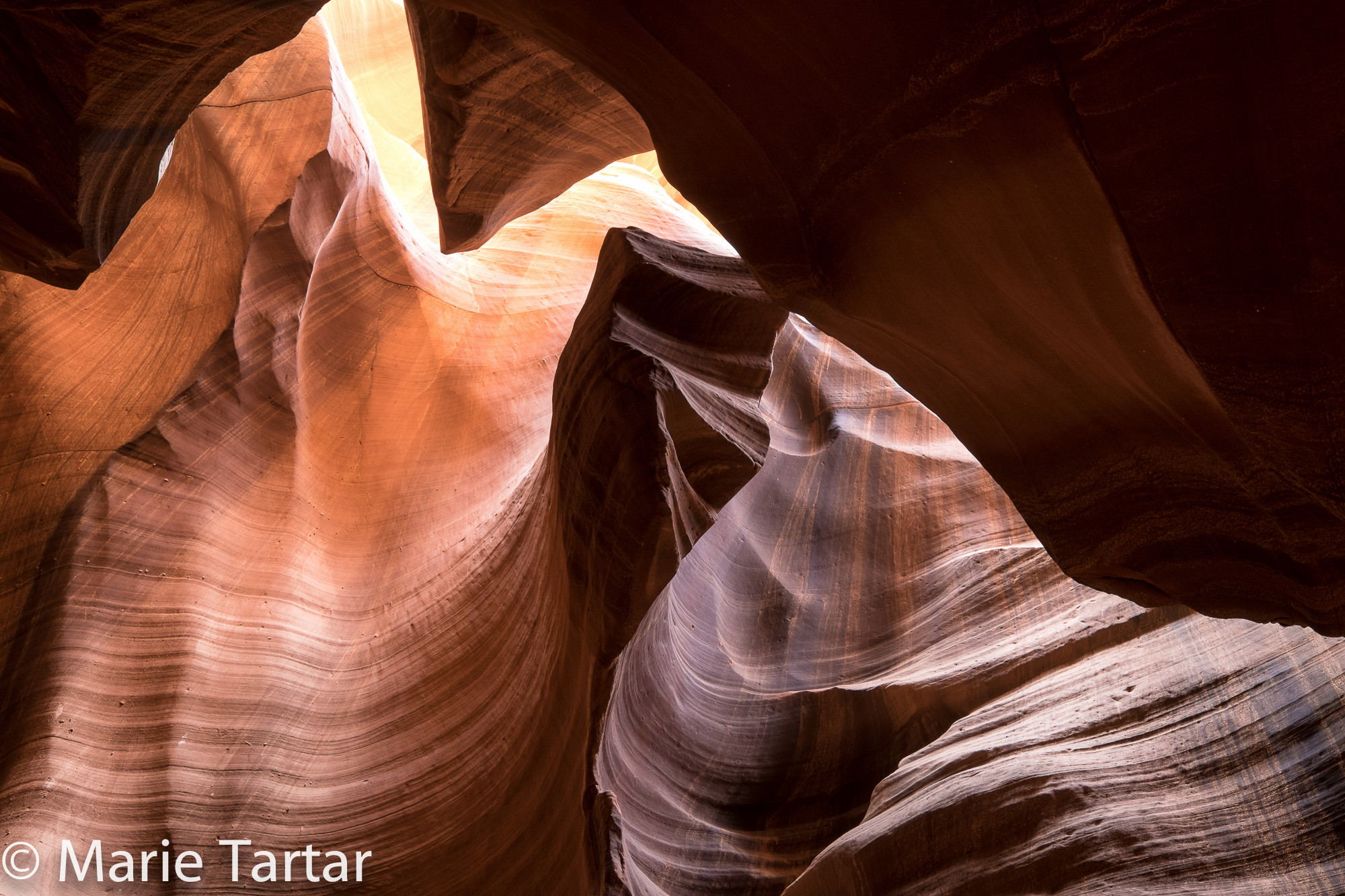
Later in the morning, our group (including me, Steve, Greg, Joe, Beth, Jennifer, Michelle, André and Jack) went to Lower Antelope Canyon. This is the tighter and narrower portion of the canyon, with the below ground entry negotiated by permanently installed metal ladders. This is also the site at which the potential danger of slot canyons and flash flooding was forever demonstrated by the tragic incident in 1997 in which 11 international tourists were killed by an 11 foot wall of water. They were swept to their deaths by a torrent of chocolate milk colored water and debris emanating from a rain 15 miles away.
We’d been warned against changing lenses in the canyon, with extremely fine sand for a floor. Sand is pervasive in the air and infiltrates cameras even without being opened. Descending with 2 cameras with 2 different lenses (10-24 mm, and 18-55 mm) without them banging into each other and the rock walls was a little tricky, but manageable.
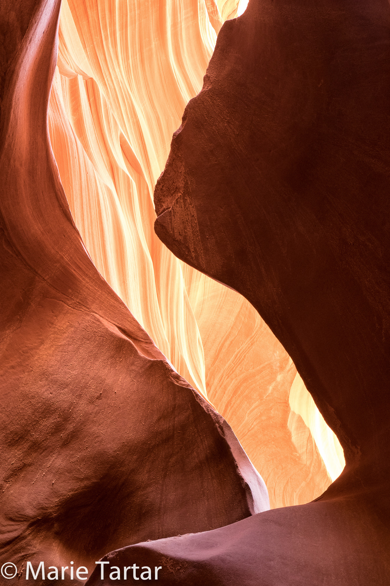
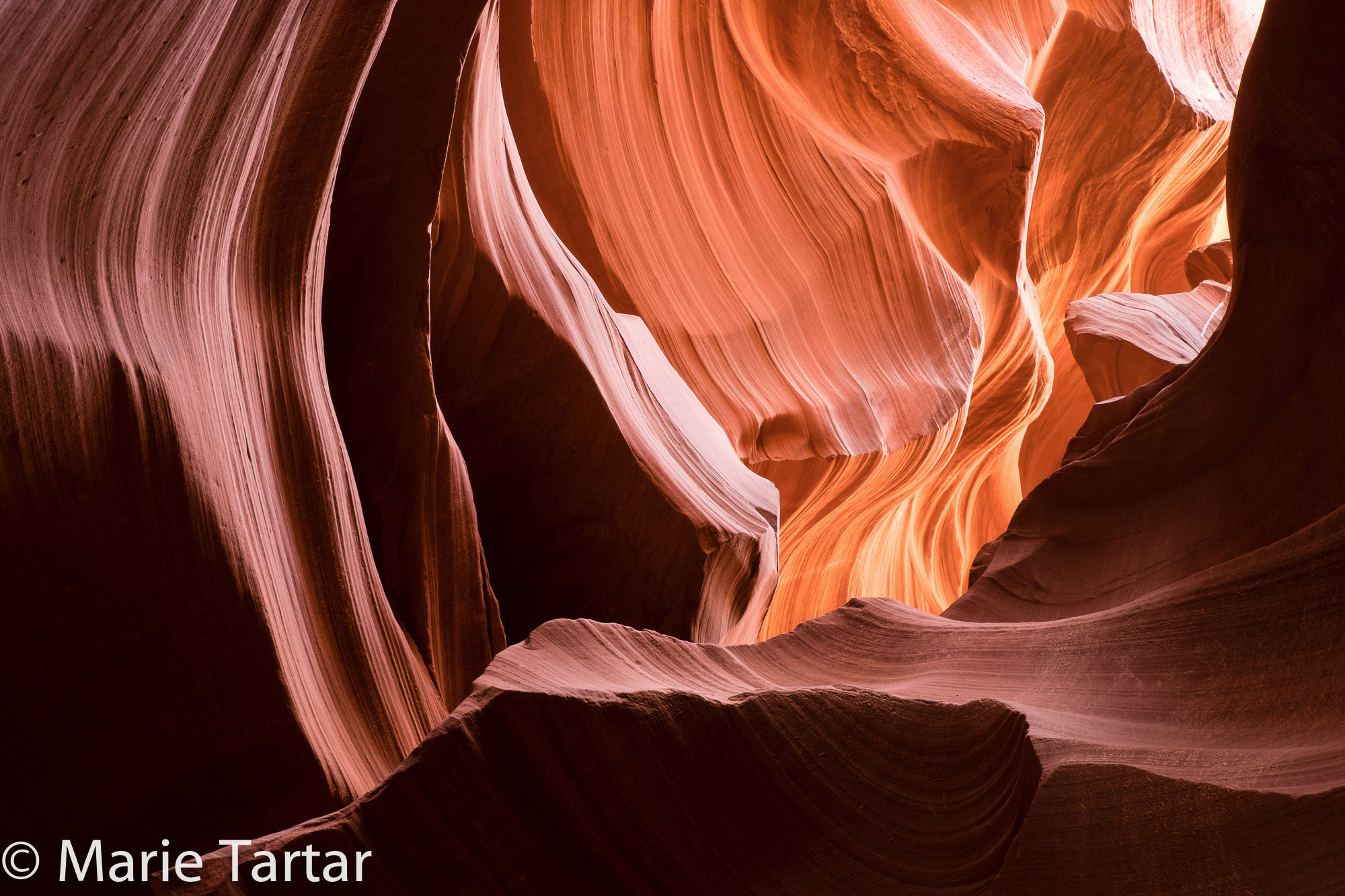
The sinuous passage is sublimely sculptural, glowing with golden and ocher hues which shade into cocoa, maroon and cimarron.
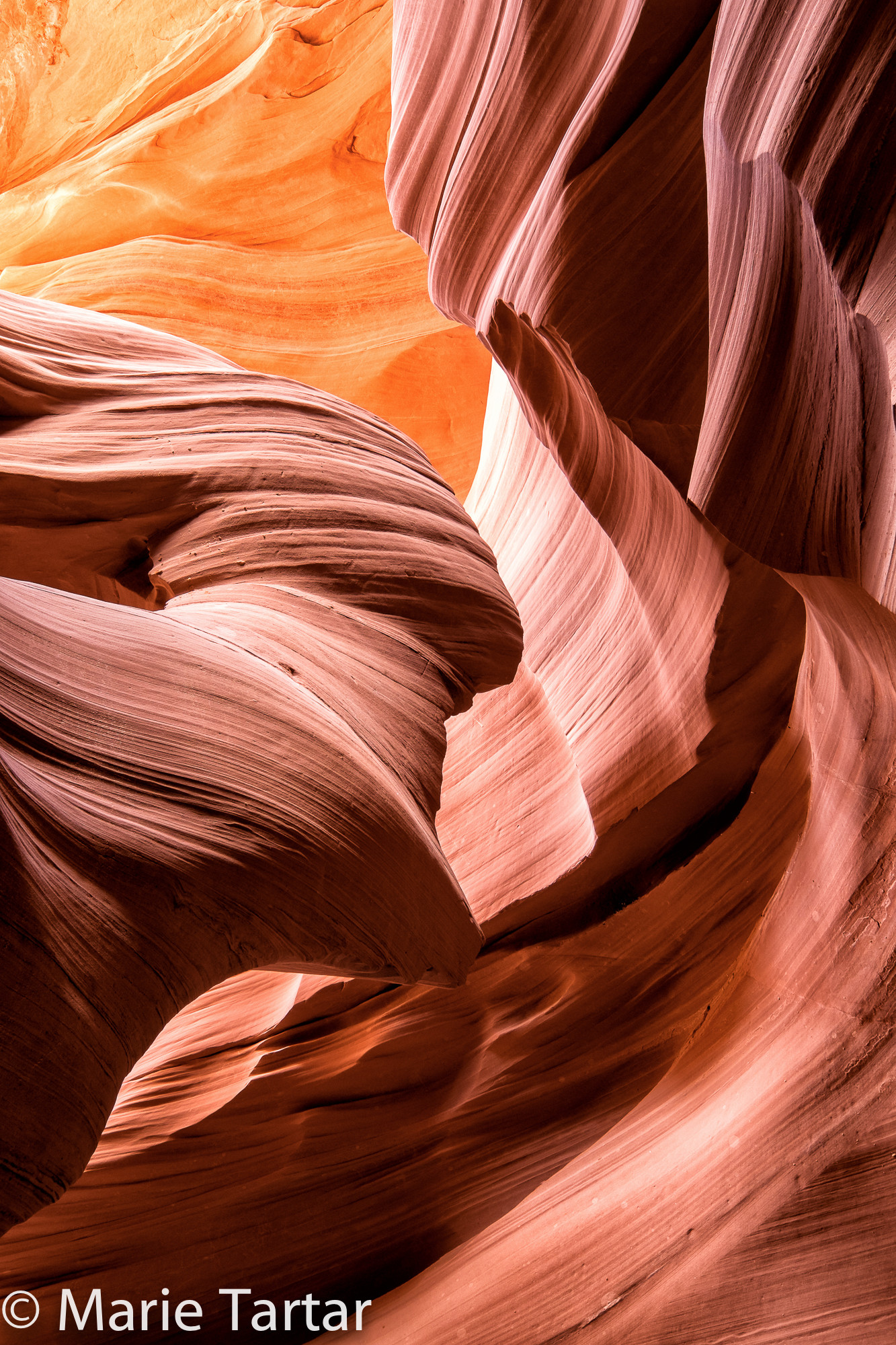
Compelling curves and compositions abound everywhere. It is jaw-droppingly beautiful, and vies for supremacy with the finest examples of nature’s handiwork I’ve seen anywhere.
Inadvertently, it seems we lucked out in being the first group to go to Lower Antelope. Although there was a steady parade of other admirers competing for position, this apparently wasn’t bad compared with what the other group encountered. We did have occasional moments of comparative solitude in some of the larger chambers.
This was in stark contrast to the Disneyland experience awaiting us the next morning at Upper Antelope. Even the access brought a theme park to mind. We had driven to Lower Antelope, walking to the entrance steps away. Arrangements had been made to let us enter through the less-utilized entrance, which also gave us precious tourist-free time. For Upper, we parked in town, and boarded an open-air trolley with two rows of seats facing out, and were driven by a guide over a sandy wash a distance that would have been a long slog on foot.
Our driver: “I don’t brake for hats!”
The entrance is at ground level, a slit in a rock face, which opens to a series of sizable chambers.
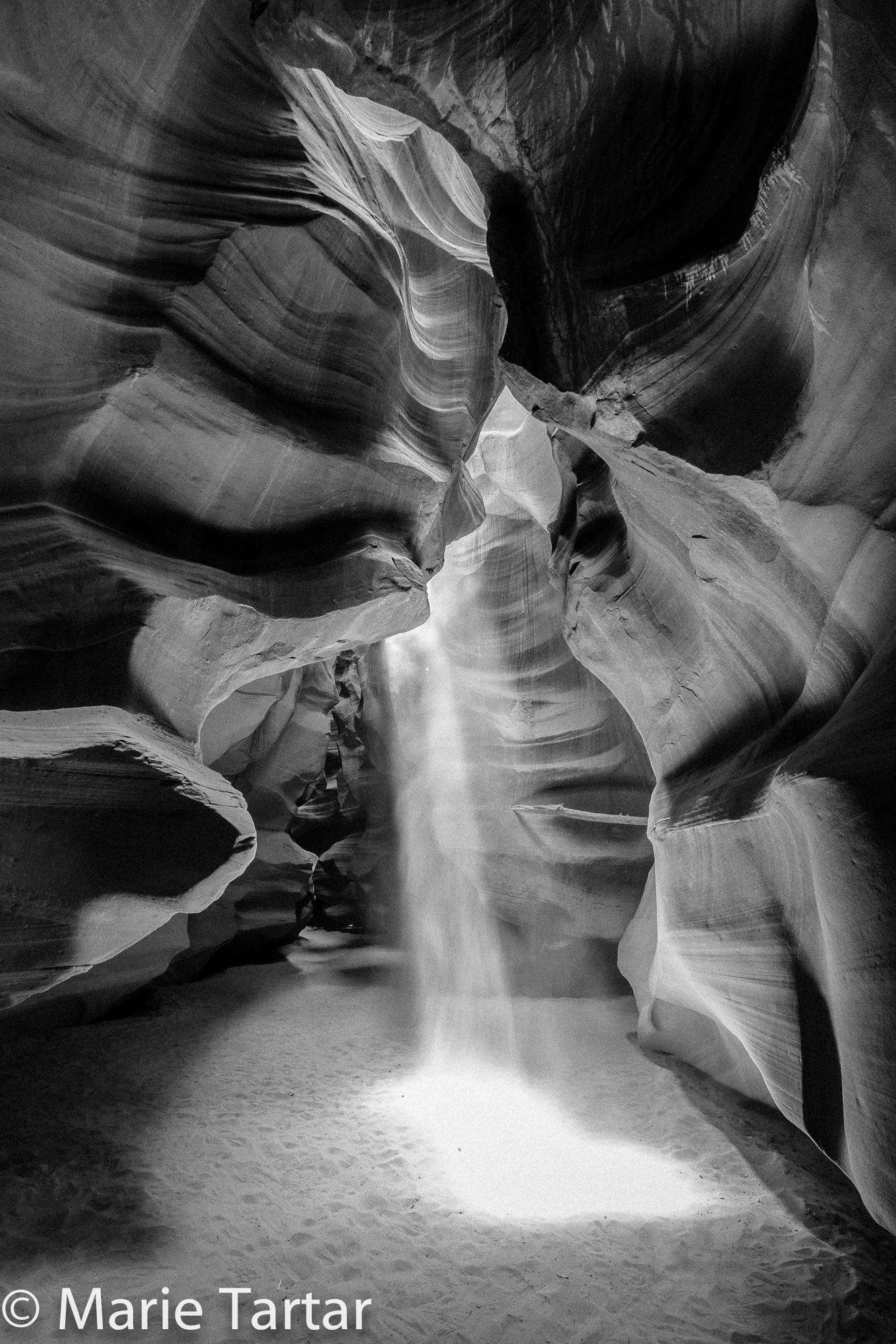
Upper narrows in places, but not to the turning sideways extent prevalent in Lower. The easier access and larger rooms allow a larger number of visitors, and they were present in abundance, including a neurosurgeon from our hospital! Thankfully, we had both Mylo and our driver to orchestrate our experience. Without them, it would have been difficult to obtain images without swarms of tourists. They hustled us from room to room, strategically holding up groups behind us. Our arrival was timed so that we would be there near the noon hour.
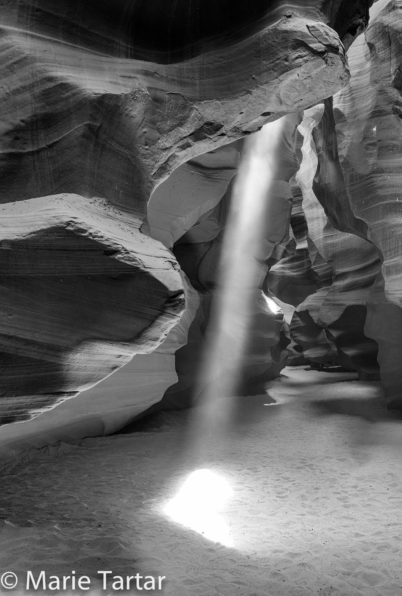
With the sun overhead, light beams emerge, which they accentuated by hurling handfuls of sand into the column.
I never realized that was how these shots are obtained. I felt like the first time I photographed the notoriously tiny and uncooperative boxer crab with the aid of a dive guide. The little creature assiduously scurried to the other side of the overturned rock, just as fast as determination not to be photographed and its tiny legs would carry it. The guide patiently, over and over, scooped it up from rock and repositioned it so I could shoot it.
“So that’s how that is done!”
And, that, it turns out, is how those signature light beam and streaming sand images of Upper Antelope Canyon are obtained-with help. Mylo showed us exactly where in the sand the light beam would end, so we could pre-focus and ready ourselves for the transient phenomenon.
The rest of our stay in Page is a blur of rising in the dark, shooting through dawn until the good light was gone, breakfasting at Ranch House Grill, mid-day review sessions, grabbing an occasional shower, then departing for the evening shoot at 4 pm or so, returning after dark for a late dinner. I was amused by the funny restaurant names we encountered: Bonkers, Slackers, Dam. Although we never made it into Bonkers, Slackers’ pepper steak sandwich yielded the best lunch of our stay, while the tilapia at the Dam Restaurant on our last night in Page was the best meal of my sojourn.
One of our dawn shoots was at Horse Shoe Bend.
The afternoon we had stopped on our way into town, it had been so incredibly windy that it seemed hazardous to stand on the edge of the cliff, much less with a tripod. Lying prone on the edge of the cliff had seemed the only plausible option. Greg had been alarmed by the depths of the plunge, and seemed to regard my creeping around the rim as the height of daring. Strangely, returning in the predawn dark seemed much less scary. We weren’t the first to arrive-when Greg and I arrived at the rim, a young man accompanied by 2 small boys zoomed out of the dark to defend his already positioned tripod on a ledge. Mylo later took him to task for venturing out onto an undermined, potentially unstable precipice.
Vermillion Cliffs, our final dawn destination, required a record early departure, at 4:20 am. The road had only recently been reopened after several years, after a section was buried in a landslide.
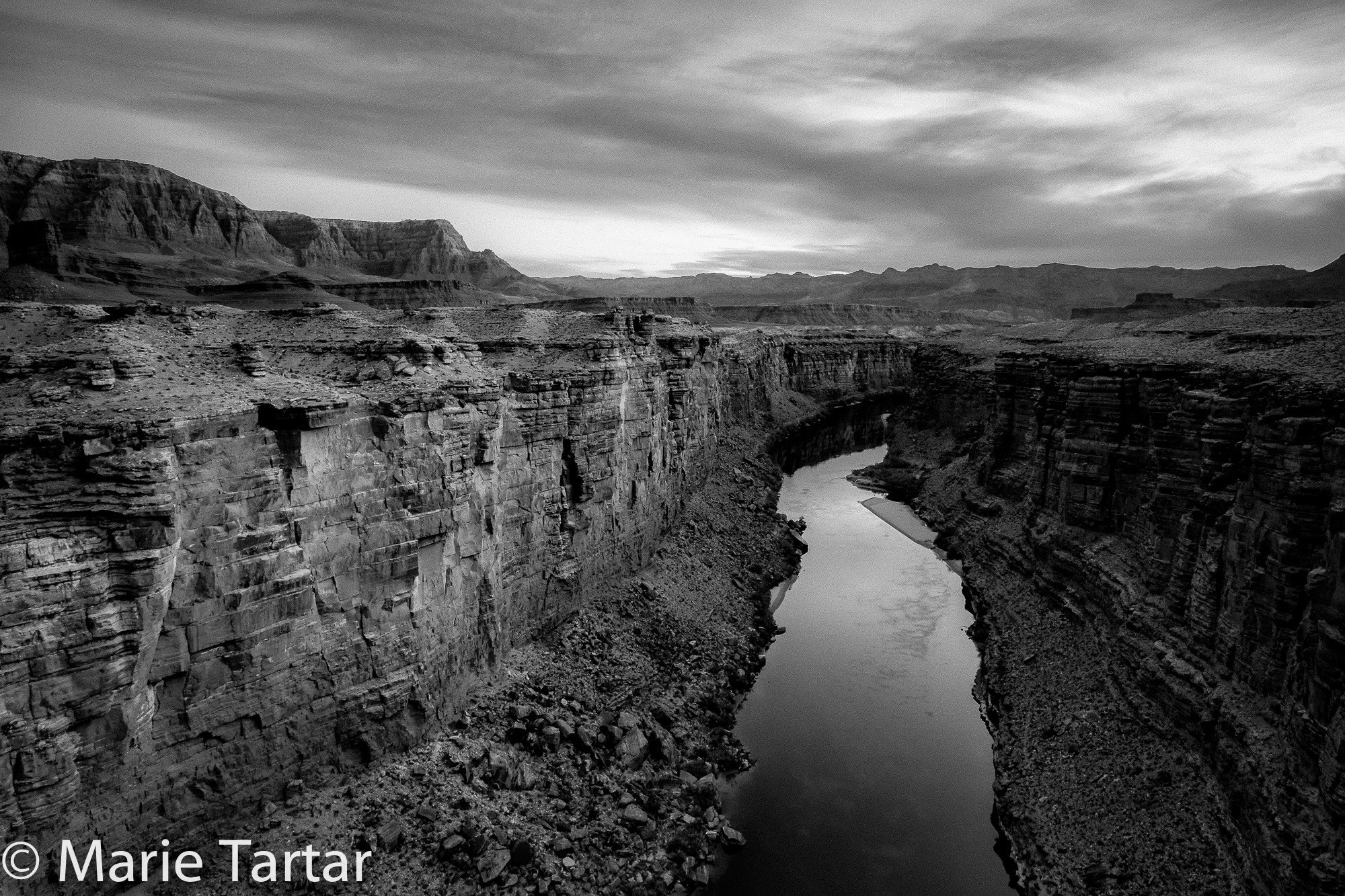
Colorado River, from Navajo Bridge
We stopped first on the Navajo Bridge to shoot the river below, then loaded up again to head for an area Jack had described as a “moonscape.”
We headed north on Saturday afternoon to Monument Valley. Jack had arranged our housing together in houses near Goulding’s which had formerly been occupied by the reservation’s doctors. Steve and I were in the master suite of the Hill House, sharing the house with Jack, Joe and Mylo. Our sunset shoot was over Monument Valley, from the grounds of the View Hotel, down the road. This was where we stayed on our prior trip in 2011, when we lucked out with both fantastic cloud formations and a full moon.
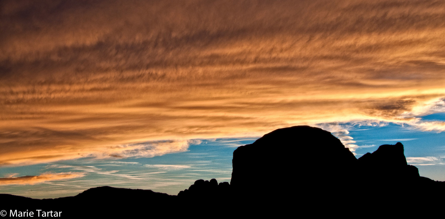
Amazing sunrise clouds shot from our room at the View, from our 2011 trip
Arriving a little too early for the best color, Steve and Greg and I headed to the opposite side of the hotel, where there is a trail on the same ridge on which the View is situated. I stopped a few times en route to shoot, and was surprised on ascending the trail to see Steve and Greg up quite a bit higher than we had ever ventured on our prior stay. From the timidity he initially manifested on the edge of the Grand Canyon and Horseshoe Bend, Greg had somehow been transformed into Greg the Goat, assuring me their perch wasn’t as bad as it looked. We shot the sunrise from this elevated airie, arriving last to dinner at Goulding’s.
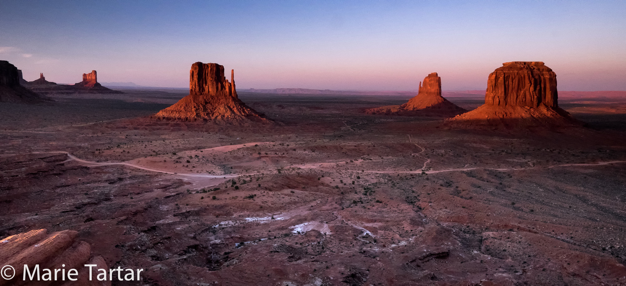
Monument Valley sunset
The Hill House was the scene of an optional night shoot of which Greg and I took advantage, despite the short night. Goulding’s is backed by imposing rock formations. Taking advantage of the lights on in the house, we prefocused on infinity, threw our apertures as wide as they would go (f2.8), and attached our cable releases. We set up tripods in the backyard, and aimed the cameras in the general direction of the monolith looming in the backyard. It was so dark, it was difficult to frame, especially once we shut the house lights off. Getting the framing right took some trial and error-studying a test shot, zooming in or out, swiveling left or right, to try to encompass the formation. Exposures were from 15-25 seconds. Sometimes a passing car would light up the road below, prompting a repeat. It was fun, and I definitely see more of this type of photography in my future.
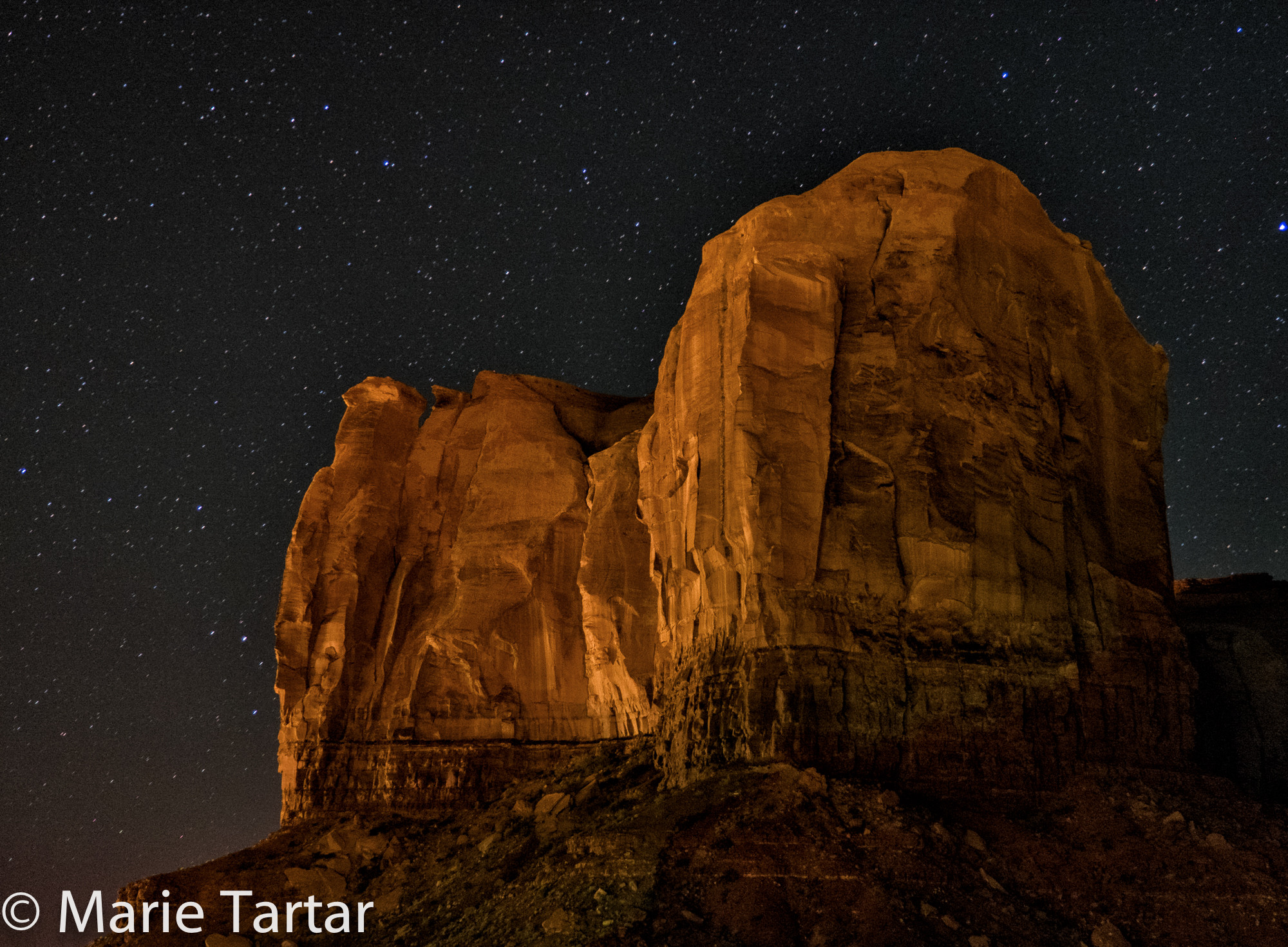
Monolith in Monument Valley, in which Goulding’s is nestled
The final Sunday morning of the workshop required rising at 4:30 am in order to be in the View Hotel’s parking lot by 5:15 am.
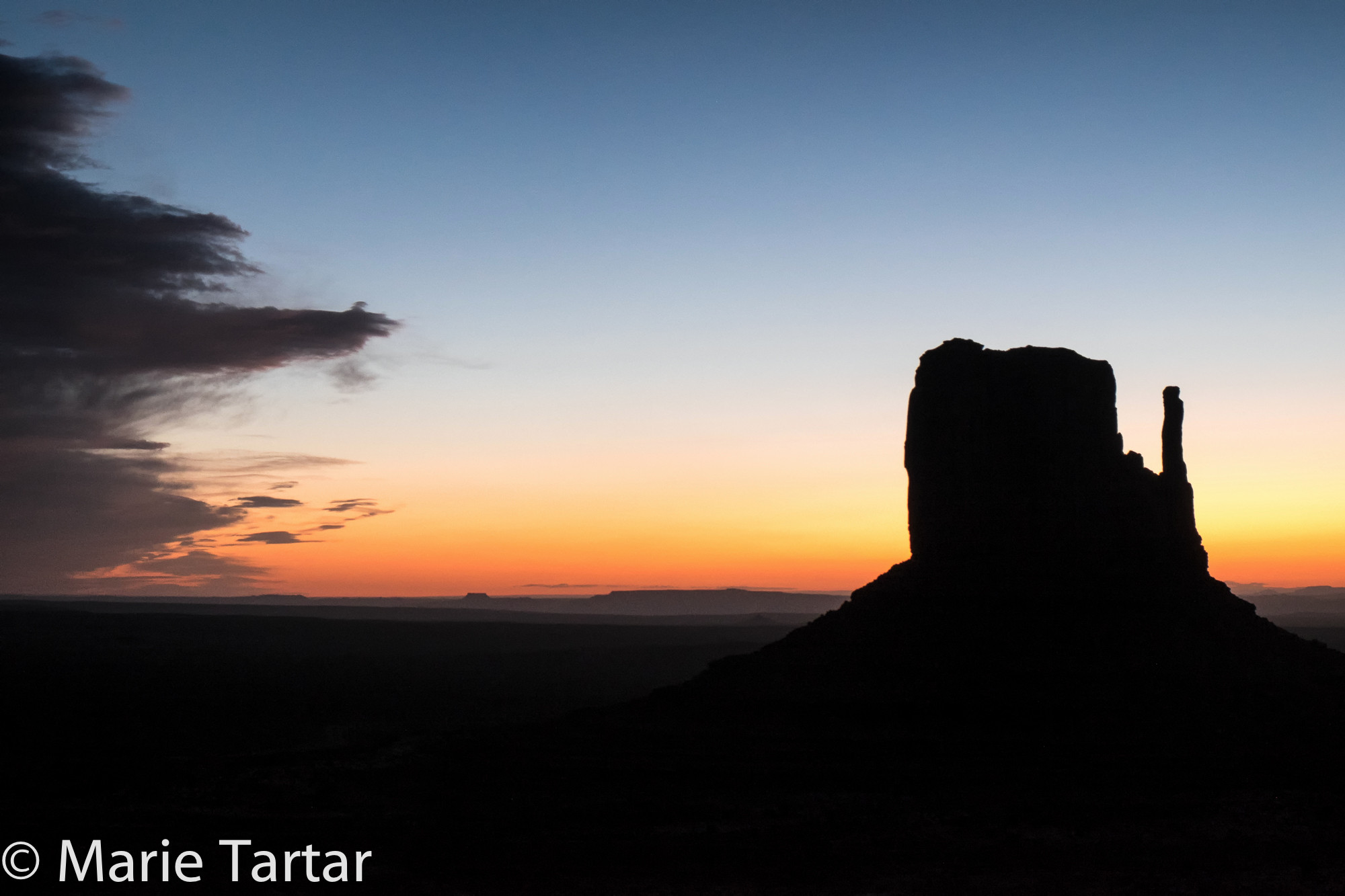
Monument Valley mitten at sunrise
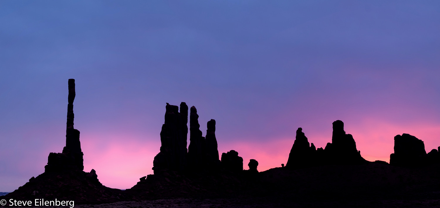
We had just a few minutes to shoot the mitten’s silhouettes before piling into a fleet of waiting Suburbans to descend onto the sandy road below to the Totem formation. Steve and I had shot these sculptural formations on our prior trip, silhouetted against a pink and blue predawn sky.
This time we had the early sun to our backs, and the formations were set off by rippled sand dunes leading up to them, and a complementary array of fabulous striated clouds behind them.
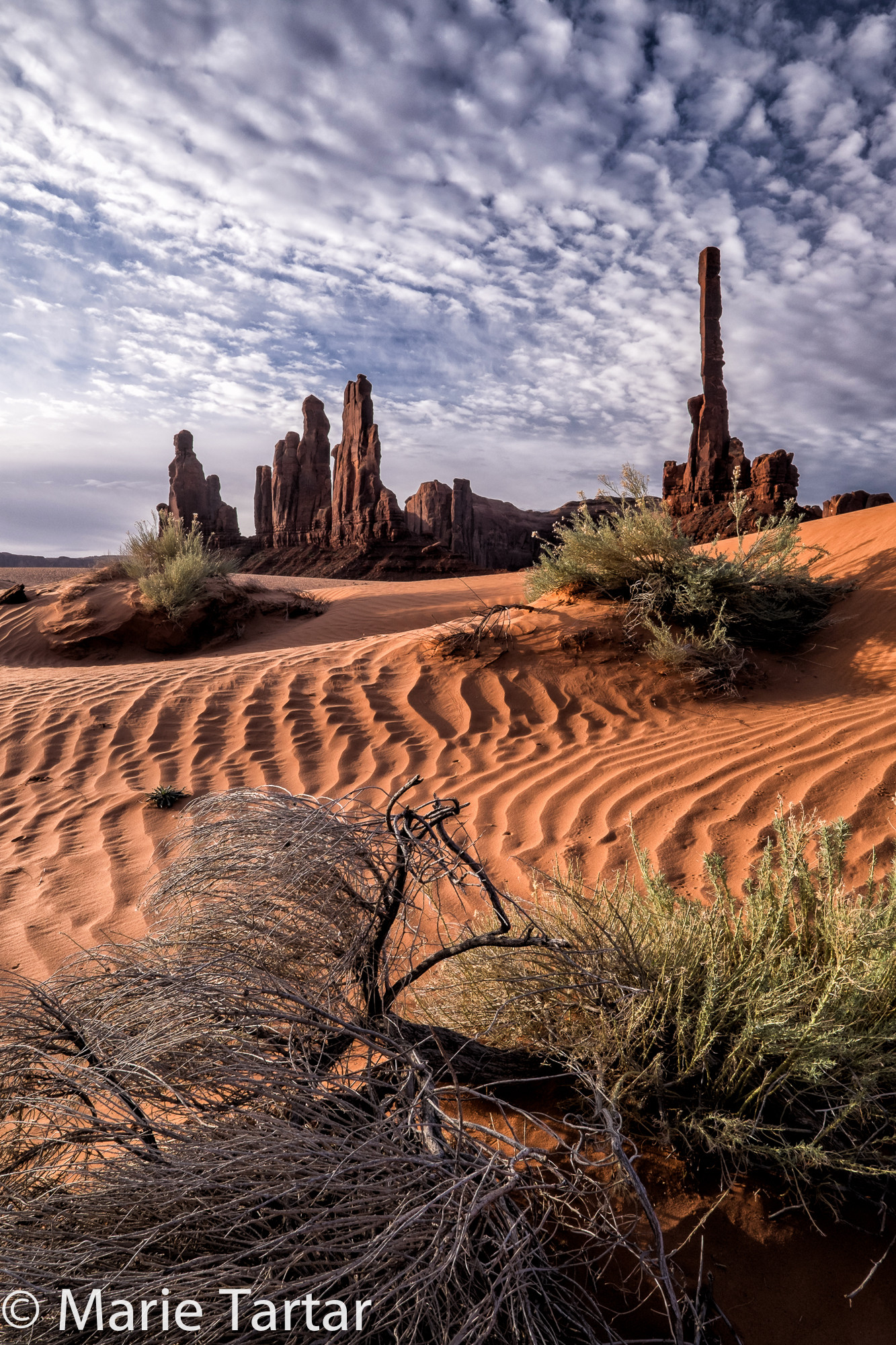
Monument Valley’s “Totems”
Our guiding team hustled us from site to site, not letting us dawdle in an unfocused way. It was well coordinated to maximize our one morning’s shoot.
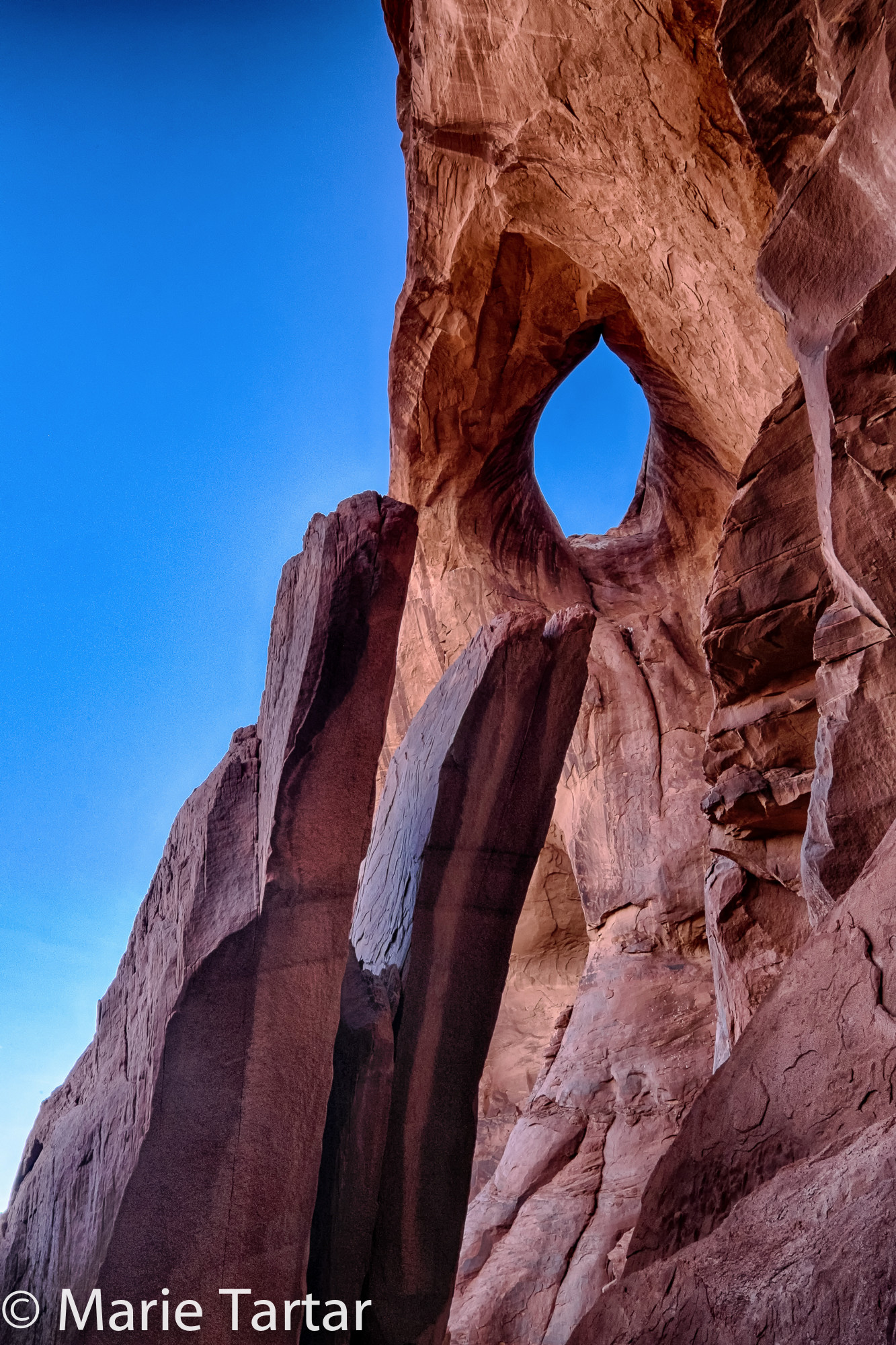
Eye in the sky, complete with eyelashes, in Monument Valley
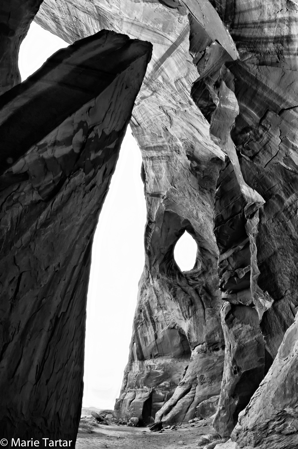
From our 2011 trip to Monument Valley, a different take on Eye in the Sky
It was wonderful to see the “Eye in the Sky” and “Ear in the Wind” formations again.
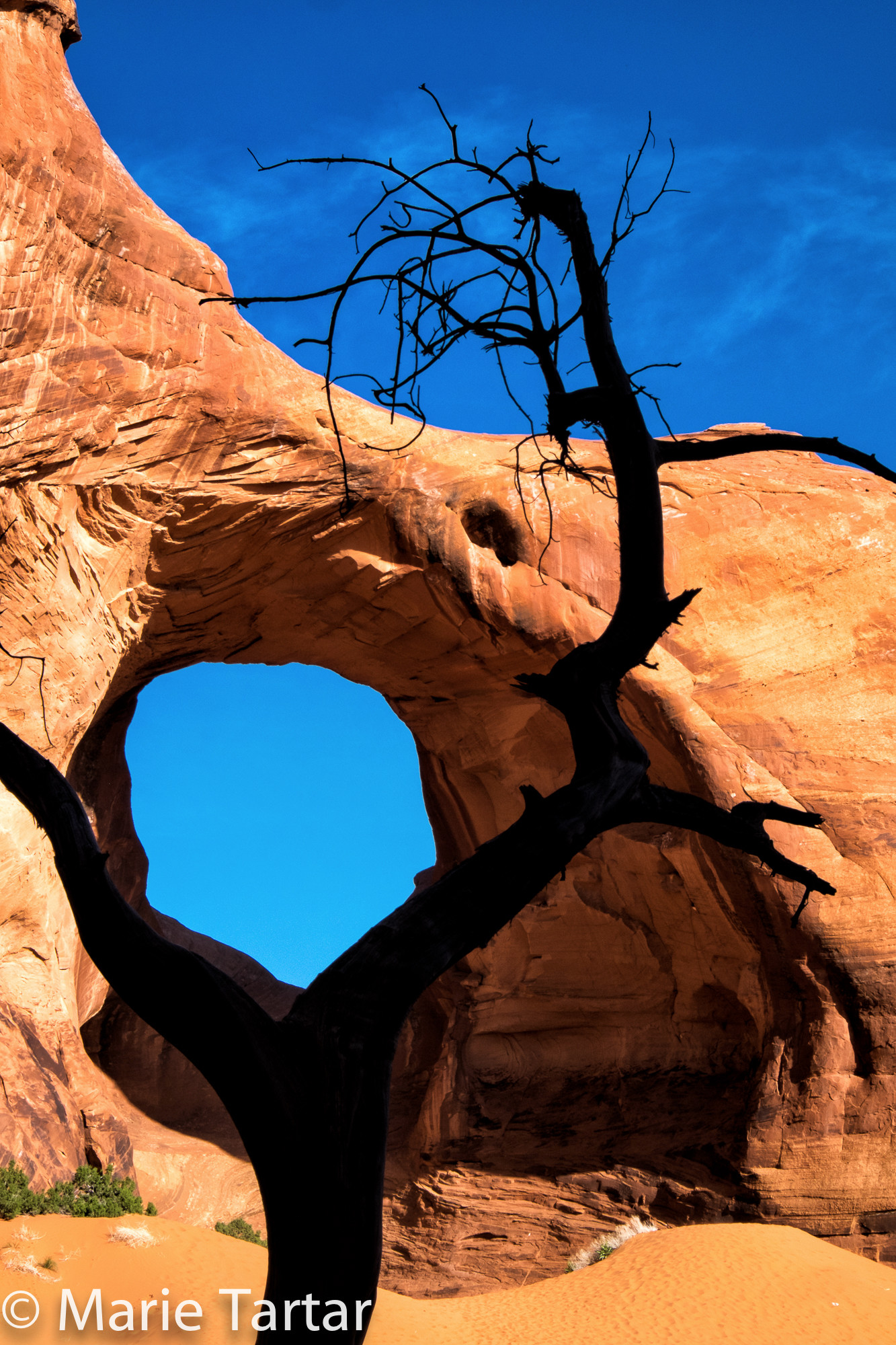
“X” makes the spot where this sculptural dead tree lines up with the aperture of the “Ear of the Wind”
Mylo treated us to a concert at our final stop, the “Big Hogan,” a natural amphitheater. The acoustics were wonderful for the melodies he spun out on his Navajo flute, a fluid and beautiful sendoff from an unforgettable sojourn in his homeland.
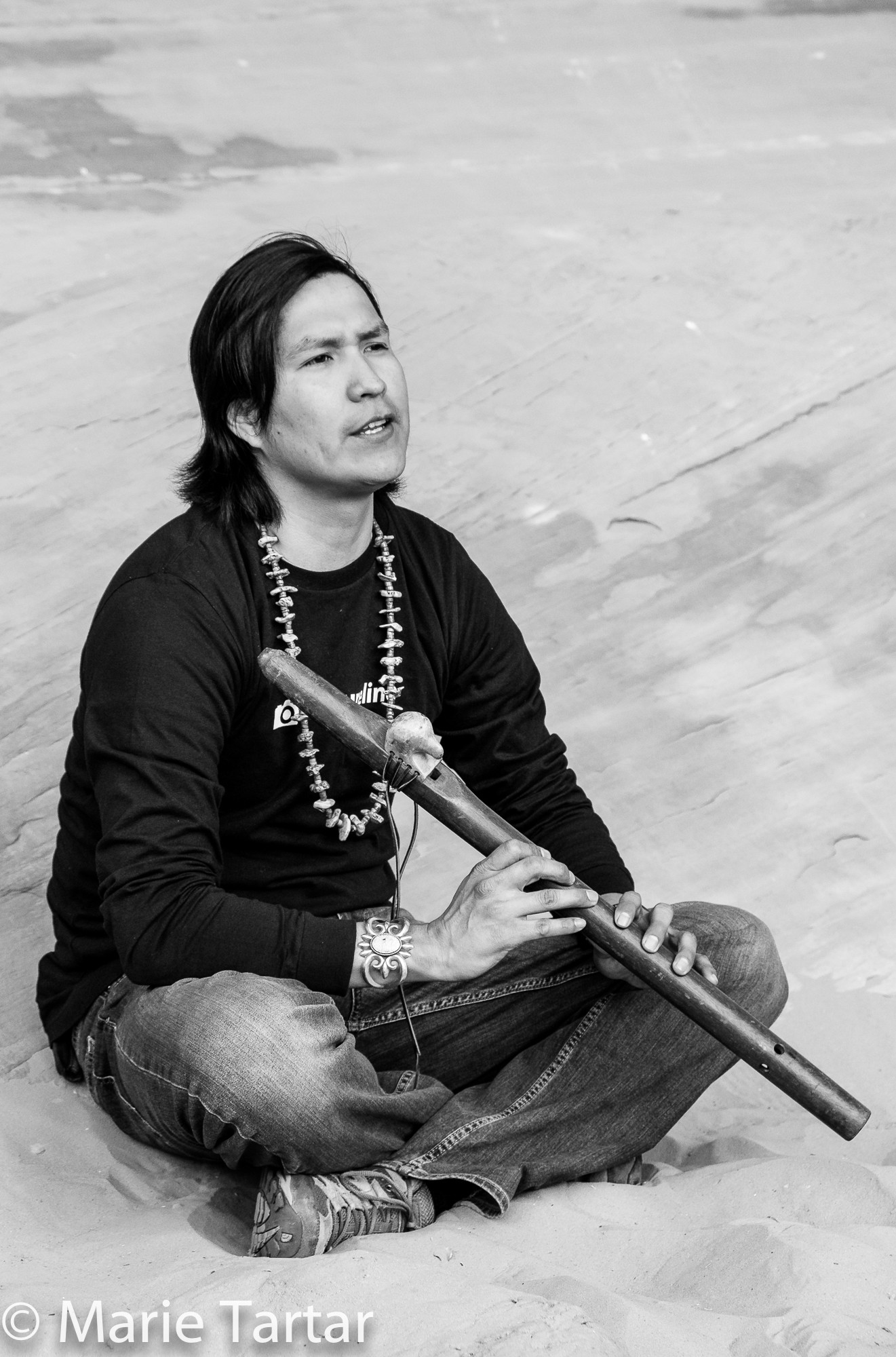
Mylo Fowler, not only an accomplished photographer, guide and linguist, sent us off with Navajo flute tunes
By noon, we were mobilizing to head our separate ways. Jack had left us at dawn, heading for Oregon and a rendezvous with his opthalmological surgeon. Steve, Greg and I loaded up for an overnight in Sedona. Even our return was an inadvertent adventure. Heading south from Flagstaff, we missed the turn-off for the scenic and most direct route, down gorgeous Oak Creek Canyon. We never take the I-17 route unless forced to by a blizzard. Before I knew it, Steve had committed us to the highly scenic, but extremely rough and rocky dirt option, Schnebly Hill Road, which descends the Mogollon Rim. We’ve only been on this road a couple of times, and most people experience it being driven by professionals maneuvering Jeeps as far as Schnebly Hill Vista. The road is only 13 miles long, how bad could it be? Well…suffice to say, Greg left with a taste of another classic Sedona tourist activity, 4-wheel driving, not in a Pink Jeep, but in a charcoal grey-completely-disguised-by-pink-dust Audi Q5 SUV. It was terrifying…and exhilarating. To give an idea how rough the road is, a little history. Sedona was settled in 1876. To reach Flagstaff, now a 45-50 minute drive up Oak Creek Canyon, then took 4 DAYS! Schnebly Hill Road was constructed over years, beginning in 1896, with improvements in 1902, reducing the trip to 2 days! This was the main route from Sedona to Flagstaff until the current State Route 89 up Oak Creek Canyon was completed in 1914.
Happily, no axles or other critical parts of the vehicle were sacrificed to the historic scenic road gods. We still returned in time for Pisco Sours and Steve’s famous beer-infused pressured cooked and roasted chicken and brussel sprouts, and Greg and I trained our tripods on the back patio toward Steamboat and Shiprock, trying to consolidate the shooting pinpoint stars lesson of the night before. All too soon, it was time to drop Greg off at the Phoenix airport, before heading on our final leg home from a most memorable red rock adventure.
-Marie
To see more images, click on this link
I enjoyed reading and sorry about your hand, yikes! you should upload a note for us from your flute :0